Our drone-assisted solutions enhance safety, precision,
and sustainability in wildlife operations.
Habitat Removal & RPAS Herbicide Application
Wildlife Surveys & Sweeps
Wildlife Prevention & Deterrence
Wildlife Observation & Monitoring
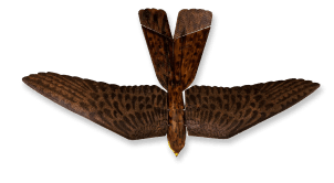
Wildlife Control, Hazing & Removal

Vegetation conditions often drive wildlife activity around operational sites. Our drone-based herbicide applications help reduce habitat attractants and support safer environments.

A sample area of problematic vegetation growth in tailings operations.

Spray Drone Operation.
Bear snout visible in den entrance.
Intent
Technology Utilized

LiDAR, imagery and analysis in the identification
of Bank Swallow nesting areas.

The RoBird™ system is our flagship wildlife management solution. Built on biomimetic drone technology, it replicates the presence of a natural predator to effectively deter birds.