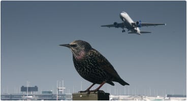
Drone solutions for Airports and Aviation

In 2021 AERIUM’S RoBird® successfully reduced bird strike incidents by 77% at partner airports

Disruptive innovation that keeps the airspace moving, safely and effectively

AERIUM’s drone technology supports airports across North America in maintaining safer airspace while providing highly innovative solutions to manage and improve regulatory compliance.

Utilizing our proprietary drone, RoBird® — along with our geospatial intelligence and automated data and surveillance capabilities — airports can identify, assess, and mitigate potential hazards with great efficiency and results.

Our Airport and Aviation integrated drone solutions include:
Industry Challenges
AERIUM Solutions
Wildlife Mitigation
RoBird®
Infrastructure Management
Geospatial Intelligence
Data Automation and Surveillance
Safety and Security
Geospatial Intelligence
Data Automation and Surveillance
Industry Challenges
Wildlife Mitigation
Infrastructure Management
Safety and Security
AERIUM Solutions
RoBird®
Geospatial Intelligence
Data Automation and Surveillance
Geospatial Intelligence
Data Automation and Surveillance
Over 265,000 wildlife strikes with civil aircraft have been reported since 1990. It is estimated that only one quarter of bird strikes get reported.

Wildlife Mitigation

The Problem

Wildlife poses an unpredictable and costly risk for airport management. Even a minor bird strike incident can cause expensive runway shutdowns and flight schedule complications.
Just consider the following data on bird strike incidents in the U.S.
Wildlife strikes have been directly responsible for 535 human fatalities throughout aviation history.
Bird strikes conservatively cost $1.2 billion per year in damage and delays.
Current bird deterrent methods are ineffective, expensive, and can harm people and the environment.
The Solution

RoBird® – revolutionizing wildlife management

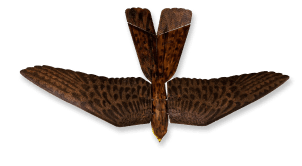
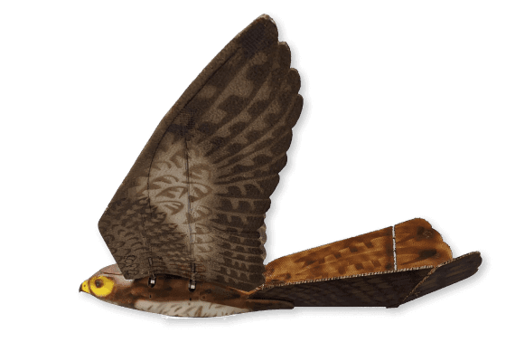
The most consistently effective bird hazing tool is a bird’s own natural enemy. RoBird® is a flapping-wing drone that mimics an actively hunting, female peregrine falcon.
Regarded as one of the most recognized and feared of all birds of prey around the globe, RoBird® naturally, humanely, and safely leverages the characteristics of the peregrine falcon to scatter and reduce bird populations near airfields
Supported by AERIUM’s advanced drone operating techniques RoBird® has proven to drastically reduce bird strike incidents at airports.
Aerium Analytics | Drone Technology Solutions - RoBird® (Wildlife Management)

Wildlife can be unpredictable, but it doesn’t have to be.

Infrastructure Management + Safety and Security

The Problem
The Federal Aviation Administration and Transport Canada mandate explicit airport runway surface maintenance, approach path monitoring and airport safety regulations.
Significant time and resources are spent overseeing and upkeeping large areas of land to ensure regulatory compliance.
Foreign Object Detection (FOD) and perimeter checks at a single airport typically produce CO2 emissions equivalent to almost 35,000 litres of gasoline consumed.
On average the cost of OLS to a Canadian airport is C$100,000 per inspection. Inspections also require runway closure which significantly adds to the induced cost.
Runway surface inspection at Calgary International Airport typically requires up to three days of runway shutdown. AERIUM can obtain the same data in four hours.
The Solution
Fast and hyper-accurate inspections, foreign object detection, and perimeter threat detection are now possible with advanced drone technology.
AERIUM supports the maintenance of safe and compliant airports utilizing Geospatial Intelligence and Data Automation and Surveillance drone technology solutions. Site and runway inspections are conducted by highly qualified and certified drone pilots utilizing high-resolution imagery and LiDAR.

Geospatial Intelligence

Data is king. Drone technology is the optimal vehicle to obtain those rich and revolutionary insights.
AERIUM solutions have proven to complete surveying and data collection services in much shorter timeframes than traditional methods. Significantly reducing costs and ensuring high levels of safety and compliance.

Learn more about Geospatial Intelligence solutions:

Automated Data and Surveillance

Leveraging deep knowledge of geographic information system (GIS) applications to provide best-in-class deliverables.
AERIUM’s team of machine learning and computer vision specialists are turning data into action. Through the development of real-time, automated detection and compliance solutions, we are helping our clients with actionable and auditable results.

Learn more about Data Automation and Surveillance solutions:

Recent success stories

Aerium Analytics | Drone Technology Solutions - Airports and Aviation

A Global Leader in Drone Innovation

Learn how we are working closely with the Edmonton International Airport on pioneering new drone applications and developing innovative solutions to modernize supply chains and enhance airport safety and performance.
Aerium Analytics | Drone Technology Solutions - Airports and Aviation

AERIUM’s flagship product, RoBird® is the most humane choice

By tying into natural avian flight or fight responses rather than adding unnatural human stressors, RoBird® is able to safely remove birds without harming or killing them.

We believe collaboration drives industry solutions

We are proud of our close industry partnerships. Our partners include NAV Canada, the Federal Aviation Administration, the National Research Council of Canada, and more.

Adding AERIUM to your fleet

Reduces time and labour required for manual inspections
Limits runway downtimes and delays
Slashes harmful environmental impacts including C02 emissions

See RoBird® in action

RoBird® has been deployed in airport and energy industry settings thousands of times with zero safety incidents.
Play Video

Meet our flight crew

We pride ourselves on our comprehensive regulatory and safety credentials, including our AERIUM drone pilots who are certified under both Transport Canada and the Federal Aviation Administration (U.S.).

Contributing to Canada’s economic growth

Driving the research, development, and commercialization of Beyond Visual Line of Sight (BVLOS) technology
Project SkySensus is just one of the ways in which AERIUM is partnering with key stakeholders to to develop advancements and innovation of unmanned systems operations, airworthiness standards, and training, in addition to advancing the regulatory landscape in Canada.

Do you want advance notification of developments in aviation and airport drone technology?

Let’s chat about how AERIUM can help your organization soar.