Summary:
- Drone Market’s rapid Growth and New Regulations
- Small and Regional Airport’s Challenges
- A brief overview of Approach Path Obstacle Analysis & Visualization
- How Drones are disrupting Approach Path Obstacle Analysis & Visualization
- Regulatory Compliance
- Our Contribution to the Future of Drone Technology in Airports
1. Rapid growth of the drone Market and New regulations
Huge industries like aviation, energy and forestry are increasingly using drones to boost operational efficiency, staff safety and reduced costs.
As drones become more commonplace, it has become clear they are a game changing technology not only within the transportation network but for society at large. Drones are modernizing the way industries work, improving people’s lives, and providing public benefits to communities.
Amid this sharp growth on drone technology usage and the need to adapt to these changes, Transport Canada released a new report in March 2021, Transport Canada’s Drone Strategy to 2025.
To read more about “Transport Canada’s Drone Strategy to 2025 ” click here.
Therefore, AERIUM Analytics leverages the transformative potential of drones and is committed to pioneering innovative applications to meet industry demands and regulatory requirements.
How is the growing adoption of drone-based solutions by airports helping to tackle the challenges faced by airports around the world?
The answers to this question will be addressed in our new series of posts on the airport challenges we are helping to solve, you’ll find it on our website, social medias, and AERIUM’S Alliance (Subscribe to our newsletter clicking here).
What’s the potential Value of drone-based solutions for airports like yours?
- Enhanced Data Accuracy: High-resolution imaging and advanced sensors provide precise data, leading to more informed decisions and better outcomes.
- Enhanced Human Safety: Minimizing bird strikes by aircraft and Protecting field crews from harmful interactions.
- Regulatory Confidence: Drone-based solutions ensure that clients meet all necessary regulatory requirements, reducing the risk of non-compliance and associated penalties.
- Wildlife protection: Minimizing impacts to critical habitat, Reducing wildlife deaths with hazing and deterrence.
- Sustainable Practices: Drones offer an environmentally friendly alternative to traditional methods, supporting clients’ sustainability goals.
- Cost Savings: By automating tasks and reducing the need for manual labor, clients can achieve significant cost reductions.
In the first blog of this series, we are addressing how drones are disrupting Approach Path Obstacle Analysis & Visualization for small and regional airports, up to Aerodrome Reference Code AGN IIIB in Canada.
2. Small and Regional Airport’s Challenges
Small and regional airports are vital in connecting communities and bolstering local economies, and being in smaller, rapidly developing regions, regional airports witness daily changes in the landscapes around their runways and terminals.
Unlike larger international airports, which often have substantial budgets and expansive landscapes, smaller airports may struggle with the financial costs of conventional methods, like helicopters.
“A prime example for small regional airports is that a single person often performs multiple roles, requiring reliance on consultants and engineers for support. Drones can address key points from cost savings to enhanced data accuracy and regulatory trust. This allows airports to maximize data acquisition and regulatory compliance at a reasonable cost, particularly with drone-based Approach Path Obstacle Analysis and Visualization.” – Michael Couch, Sr. Sales Account Manager – Airports at AERIUM Analytics.
3. A Brief overview of Approach Path Obstacle Analysis & Visualization
Approach paths are invisible boundaries around airports that ensure the sky near runways is clear of obstacles like buildings, fences, trees and powerlines, among others, keeping flights safe during takeoff, landing, and flying nearby. In other words, it defines the airspace around runways where obstacles must be controlled. Approach Path Obstacle Analysis and visualization, also known as Obstacle Limitation Surface (OLS) surveys, in Canada, plays a crucial role in maintaining safety, compliance, and efficiency.
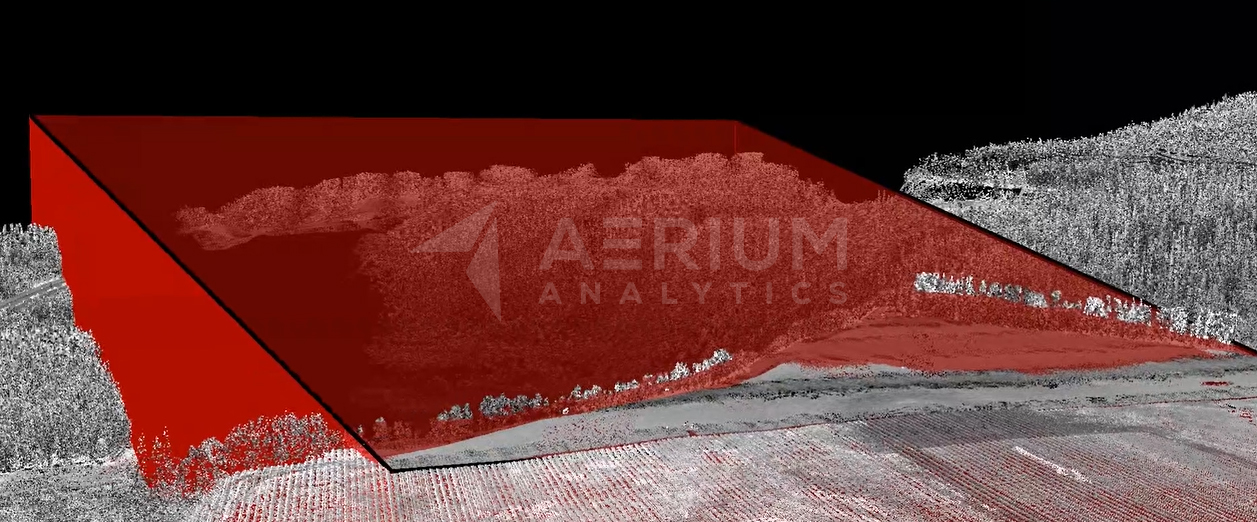
Figure 1: 3D illustrative example of Approach Path Obstacle Analysis and Visualization
Protecting approach paths from obstructions can be challenging without the right tools. Many airports still rely on traditional Approach Path Obstacle Analysis and visualization methods, including ground-based observations and manned aircraft surveys, but some limitations of these conventional methods include:
- High Costs
- Limited Accuracy and Visibility
- Time-Consuming Processes
4. How Drone are disrupting Approach Path Obstacle Analysis & Visualization
Drones are disrupting the way Approach Path Obstacle Analysis and visualization is conducted by offering several key advantages:
- Comprehensive Data Accuracy and Improved Coverage: Drones equipped with Light Detection and Ranging (LiDAR) capture detailed data from various angles and heights, ensuring comprehensive coverage of the Approach Path Obstacle Analysis and visualization area.
- Cost-Effectiveness for small to medium-sized Airports: Drone-based surveys offer a cost-effective alternative to traditional methods, making them accessible for smaller regional airports by eliminating the need for expensive aircraft.
- Advanced Data Visualization Techniques: Drones deliver clear, detailed 3D models and maps for Approach Path Obstacle Analysis and Visualization, pinpointing obstacles like power lines and radio antennas.By simplifying complex data, drones enable informed decision-making and effective communication with stakeholders. This is especially valuable for airports for conveying technical information to non-experts. Additionally, drones offer these benefits cost-effectively, making them an efficient solution for maintaining safety and compliance
- Enhanced Safety Measures: By deploying drones, airport operations managers can mitigate risks associated with working in hazardous environments near active runways or challenging terrains.
Drones are transforming Approach Path Obstacle Analysis and visualization by offering a cost-effective and efficient alternative, especially for small to medium-sized airports. This innovative approach ensures that even smaller regional airports can maintain high safety standards without the prohibitive costs associated with traditional methods.
5. What about Regulatory Compliance?
Approach Path Obstacle Analysis and visualization are crucial for regulatory compliance with national and international aviation safety standards.
Here are some examples of how these regulations are managed:
- Transport Canada: In Canada, Transport Canada’s TP 312 5th Edition outlines specific requirements for OLS, ensuring airports comply with national safety regulations. This includes the dimensions, slopes, and maintenance of OLS to protect critical airspace.
- The Federal Aviation Administration (FAA): In the United States, the FAA’s FAR Part 77 outlines specific requirements for safe, efficient use, and preservation of the navigable airspace. This includes the standards used to determine obstructions to air navigation, and navigational and communication facilities.
- International Civil Aviation Organization (ICAO): ICAO, a specialized agency of the United Nations, sets global aviation safety standards. Approach Path requirements are detailed in ICAO Annex 14, which prescribes the dimensions and slopes of various surfaces to maintain obstacle-free zones around airports.
To be compliant, airports must adhere to several key requirements:
- Regular Surveys: Airports must conduct regular Approach Path Obstacle Analysis and visualization to identify and assess potential obstacles to ensure that any new structures or natural growth (e.g., trees) are detected and managed promptly. Unlike traditional methods that might be slow and resource-intensive, drones can quickly cover specific areas, detecting new structures or natural growth with high precision.
- Obstacle Management: Obstacles must be managed or removed to maintain clear Approach Paths. This involves trimming trees, demolishing structures, or implementing height restrictions on new developments near the airport. Drones high-resolution imaging and advanced sensors enable accurate identification and monitoring, helping airports make informed decisions about tree trimming, structure removal, or development restrictions.
- Documentation and Reporting: Airports are required to document their Approach Path assessments and management actions. The documentation must be submitted to regulatory authorities to demonstrate compliance and receive or maintain airport certification. Drones simplify the documentation and reporting processes. They generate detailed 3D models and maps that clearly illustrate obstacles and the status of approach paths. This digital data is easier to compile, analyze, export, and submit to regulatory authorities, ensuring compliance with minimal administrative overhead.
- Continual Monitoring: This is necessary to ensure ongoing compliance and includes both periodic surveys and continuous observation of potential obstacle areas. Drones provide ongoing, continuous monitoring of approach paths, offering regular updates and real-time insights into potential obstacles. This dynamic monitoring capability surpasses traditional methods, which may rely on periodic, static surveys. Drones ensure that airports maintain up-to-date compliance and swiftly address any emerging issues.
6. Our Contribution to the Future of Drone Technology in Airports
“Drones represent more than just tools for us; they embody the essence of innovation and the potential to catalyze transformative change. Gaining increased airspace access signifies a milestone achievement, a testament to our relentless pursuit of integrated and safe drone operations and visionary aspirations.” – Jordan Cicoria, President and CEO at AERIUM Analytics.
At AERIUM Analytics, our advanced drone technology is central to our Approach Path Obstacle Analysis & Visualization services. We ensure that our methods align with Transport Canada’s stringent safety standards outlined in TP 312 5th Edition.
Our S.O.L.E. (Safety Operations Learning Equipment) Safety Management System boasts a flawless track record in complex environments. This success is supported by comprehensive drone operator training and robust technology redundancies, such as geofences.
We’ve been pioneers in using drones for OLS analysis, offering unmatched expertise in digitizing data for enhanced safety and efficiency to airports. Currently, AERIUM Analytics can conduct Approach Path Obstacle Analysis and Visualization (APOAV) for airports up to Aerodrome Reference Code AGN IIIB. However, with advancements in drone technology and our ongoing R&D investments, we expect to extend our services to airports up to Aerodrome Reference Code AGN V in the near future.
We confidently navigate the most challenging regulatory approval processes globally, with a portfolio of impressive projects, including Whitehorse and Slave Lake. Notably, our work with Edmonton International Airport (YEG) further highlights our capabilities. Our ongoing projects span North America, South America, and Oceania. Learn more here: https://aeriumanalytics.com/global-leader-in-drone-innovation/
We are excited to continue leading the way in drone-based OLS analysis and digitization, and looking forward to helping you enhance your airport’s safety and efficiency.
References:
Transport Canada. (n.d.). Aerodromes standards and recommended practices (TP 312). Retrieved from https://tc.canada.ca/en/aviation/publications/aerodromes-standards-recommended-practices-tp-312
Transport Canada. (2020). TP 312: Aerodrome standards and recommended practices (Amendment 1). Retrieved from https://tc.canada.ca/sites/default/files/2023-06/TP312-ENG-05-amendment-1-15jan2020.pdf
International Airport Review. (2023). A global leader in drone innovation. Retrieved July 30, 2024, from https://www.internationalairportreview.com/article/176511/a-global-leader-in-drone-innovation/